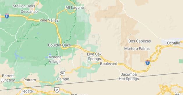
Laguna Summit – Bad Roads for RVs, is on Interstate 8 west of San Diego and Ocotillo CA. The road is steep and often has high crosswinds especially as you get near the descent into the desert. Since this is an Interstate Highway, there are at least two lanes in each direction and the curves are not part of the problem.
Laguna Summit is at the intersection of Interstate 8 and Old Highway 80, also known as the Sunrise Highway.
Make sure to check the expected wind speeds when using Interstate 8 and refer to the California Department of Transportation website for current conditions. Typically the wind speed will increase throughout the day until about sunset and then will decrease at night, repeating the pattern each day.
Caltrans and the California Highway Patrol will close this route to high profile vehicles numerous times per year.
Refer to Caltrans Quick Map for the most up to date information about this section of the road. Caltrans Quick Map
Details
Elevation: 4140 feet
Length: 50 miles
Terrain: several 4-5% occasional 6% grades for extended distances. Eastbound descent into the desert are 6% grades for 9 miles. Maximum truck speed 35 miles per hour.
Turns: There are many 50 mile-per-hour turns on both sides of the pass.
Rest Stops & Turnouts: Eastbound, Alpine Vista Point – east of Willows Road, Buckman Springs at Buckman Springs Road, serves both east and westbound traffic. Golden Acorn Casino, south of Bia Rod, serves both east and westbound traffic. South on Carrizo Gorge Road serves both east and westbound traffic. Jacumba Parking serves eastbound traffic, east of Jacumba.
Bridges: Bridges, in the winter, often will be icy.
Traffic: Most traffic, both westbound and eastbound will be east of Willows Road.
Runaway truck ramps: Eastbound descent into the desert on the right side at 5 miles down the grade.
Laguna Summit – Bad Roads for RVs — Our experience
We have traveled Interstate 8 numerous times on our travels. It is the primary eastbound route from San Diego to Yuma and points further east. We have avoided the high winds typical for the area by closely monitoring the conditions and at one time delaying our departure.
We traveled this route during our journey to Joshua Tree National Park in February 2018 in this link. Joshua Tree
We also traveled this route during our journey to El Centro in January 2020
Here is our link to our interactive map. Bad Roads for RVs

